চিত্র:Asia 400ad.jpg

এই প্রাকদর্শনের আকার: ২২০ × ১৩৪ পিক্সেল। অন্যান্য আকারসমূহ: ৩২০ × ১৯৫ পিক্সেল | ১,৯৯০ × ১,২১১ পিক্সেল।
মূল ফাইল (১,৯৯০ × ১,২১১ পিক্সেল, ফাইলের আকার: ৭৯০ কিলোবাইট, এমআইএমই ধরন: image/jpeg)

|
This historical map image could be re-created using vector graphics as a SVG file. This has several advantages; see Commons:Media for cleanup for more information. If a SVG form of this image is available, please upload it and afterwards replace this template with
{{vector version available|new image name}}.It is recommended to name the SVG file “Asia 400ad.svg”—then the template Vector version available (or Vva) does not need the new image name parameter. |


সারাংশ
| বিবরণAsia 400ad.jpg |
English: Asia in 400 AD. Displayed among others: Kushan Empire, Sassanid Empire, Gupta Empire, Huns, Tai peoples, Kidarites |
| উৎস | URL: http://www.ThomasLessman.com/History/images/East-Hem_400ad.jpg |
| লেখক | Thomas A. Lessman, en:User:Talessman |
| অনুমতি (এ ফাইলের পুনঃব্যবহার) |
Image was created by me (Thomas Lessman) based on map of Eastern Hemisphere in 400 AD. Image is free for public and/or educational use. I would appreciate a mention if this image is used elsewhere. If anyone is interested in helping further this work, please contact Thomas Lessman at [email protected]. |
| অন্যান্য সংস্করণ | এই ফাইলের উপজাত কর্মসমূহ: |

.jpg)


|
|
This historical map image could be re-created using vector graphics as a SVG file. This has several advantages; see Commons:Media for cleanup for more information. If a SVG form of this image is available, please upload it and afterwards replace this template with
{{vector version available|new image name}}.It is recommended to name the SVG file “Asia 400ad.svg”—then the template Vector version available (or Vva) does not need the new image name parameter. |
লাইসেন্স প্রদান
  
|
এই ফাইলটি ক্রিয়েটিভ কমন্স অ্যাট্রিবিউশন-শেয়ার অ্যালাইক ৩.০ আনপোর্টেড লাইসেন্সের আওতায় লাইসেন্সকৃত। দাবিত্যাগের সাপেক্ষে। | |
| ||
| এই লাইসেন্স ট্যাগটি জিএফডিএল লাইসেন্স হালনাগাদের অংশ হিসেবে এই ফাইলে সংযুক্ত হয়েছে।http://creativecommons.org/licenses/by-sa/3.0/CC BY-SA 3.0Creative Commons Attribution-Share Alike 3.0truetrue |

|
এই নথি অনুলিপি, বিতরণ এবং/বা পরিবর্তন করার অনুমতি ফ্রি সফটওয়্যার ফাউন্ডেশন কর্তৃক প্রকাশিত গনু ফ্রি ডকুমেন্টেশন লাইসেন্স, সংস্করণ ১.২ বা তার পরবর্তী সংস্করণের আওতায় অনুমতিপ্রাপ্ত; যে কোনো রকম অনুচ্ছেদ পরিবর্তন, সম্মুখ-প্রচ্ছদের লেখা, পিছন-প্রচ্ছদের লেখা পরিবর্তন করা ছাড়াই। এই লাইসেন্সের একটি অনুলিপি গনু ফ্রি ডকুমেন্টেশন লাইসেন্স শিরোনামের অনুচ্ছেদে অন্তর্ভুক্ত করা আছে। দাবিত্যাগের সাপেক্ষে।http://www.gnu.org/copyleft/fdl.htmlGFDLGNU Free Documentation Licensetruetrue |
ক্যাপশন
এই ফাইলটি কী উপস্থাপন করছে তার এক লাইন ব্যাখ্যা যোগ করুন
ফাইলের ইতিহাস
যেকোনো তারিখ/সময়ে ক্লিক করে দেখুন ফাইলটি তখন কী অবস্থায় ছিল।
| তারিখ/সময় | সংক্ষেপচিত্র | মাত্রা | ব্যবহারকারী | মন্তব্য | |
|---|---|---|---|---|---|
| বর্তমান | ২৩:৫৭, ৬ এপ্রিল ২০০৮ | 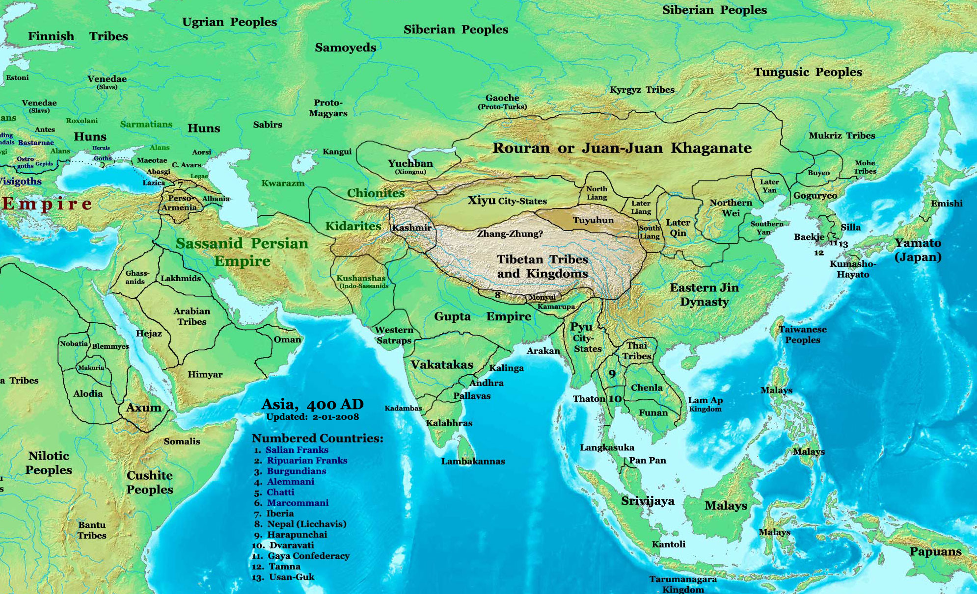 | ১,৯৯০ × ১,২১১ (৭৯০ কিলোবাইট) | smartcommons>Guillem d'Occam | Author: Thomas A. Lessman. Source URL: [http://www.ThomasLessman.com/History/images/East-Hem_400ad.jpg]. Image was created by me (Thomas Lessman) based on map of Eastern Hemisphere in 400 AD. Image is free for public and/or educational use. I would appr |
ফাইলের ব্যবহার
এই ফাইল ব্যবহার করে এমন কোনো পাতা নেই।
