চিত্র:BengalPartition1905 Map.png

এই প্রাকদর্শনের আকার: ২২০ × ১৪৬ পিক্সেল। অন্যান্য আকারসমূহ: ৩২০ × ২১২ পিক্সেল | ৩,০০০ × ১,৯৮৯ পিক্সেল।
মূল ফাইল (৩,০০০ × ১,৯৮৯ পিক্সেল, ফাইলের আকার: ১.১৯ মেগাবাইট, এমআইএমই ধরন: image/png)

সারাংশ
| বিবরণBengalPartition1905 Map.png |
English: Map of showing the partition of Lower Bengal between Bengal and East Bengal and Assam in 1905. Source data: Survey of India 1:253k (Perry-Castenada Map Library, Univ of Texas), India 1:1M, Imperial Gazetteer of India 1:4M (Digital South Asia Library, Univ of Chicago). |
| তারিখ | |
| উৎস | নিজের কাজ |
| লেখক | XrysD |

|
This image could be re-created using vector graphics as a SVG file. This has several advantages; see Commons:Media for cleanup for more information. If a SVG form of this image is available, please upload it and afterwards replace this template with
{{vector version available|new image name}}.It is recommended to name the SVG file “BengalPartition1905 Map.svg”—then the template Vector version available (or Vva) does not need the new image name parameter. |
লাইসেন্স প্রদান
আমি, এই কাজের স্বত্বাধিকারী, এতদ্দ্বারা আমি এই কাজকে নিম্ন বর্ণিত লাইসেন্সের আওতায় প্রকাশ করলাম:


এই ফাইলটি ক্রিয়েটিভ কমন্স অ্যাট্রিবিউশন-শেয়ার অ্যালাইক ৪.০ আন্তর্জাতিক লাইসেন্সের আওতায় লাইসেন্সকৃত।
- আপনি স্বাধীনভাবে:
- বণ্টন করতে পারেন – এ কাজটি অনুলিপি, বিতরণ এবং প্রেরণ করতে পারেন
- পুনঃমিশ্রণ করতে পারেন – কাজটি অভিযোজন করতে পারেন
- নিম্নের শর্তাবলীর ভিত্তিতে:
- স্বীকৃতিপ্রদান – আপনাকে অবশ্যই যথাযথ স্বীকৃতি প্রদান করতে হবে, লাইসেন্সের একটি লিঙ্ক সরবরাহ করতে হবে এবং কোনো পরিবর্তন হয়েছে কিনা তা নির্দেশ করতে হবে। আপনি যেকোনো যুক্তিসঙ্গত পদ্ধতিতে এটি করতে পারেন। কিন্তু এমন ভাবে নয়, যাতে প্রকাশ পায় যে লাইসেন্সধারী আপনাকে বা আপনার এই ব্যবহারের জন্য অনুমোদন দিয়েছে।
- একইভাবে বণ্টন – আপনি যদি কাজটি পুনঃমিশ্রণ, রুপান্তর, বা এর ওপর ভিত্তি করে নতুন সৃষ্টিকর্ম তৈরি করেন, তবে আপনাকে অবশ্যই আপনার অবদান একই লাইসেন্স বা একই রকমের লাইসেন্সের আওতায় বিতরণ করতে হবে।
ক্যাপশন
এই ফাইলটি কী উপস্থাপন করছে তার এক লাইন ব্যাখ্যা যোগ করুন
Map showing the result of the partition of Bengal in 1905. The western part (Bengal) gained parts of Odisha, the eastern part (Eastern Bengal and Assam) regained Assam that had been made a separate province in 1874.
ফাইলের ইতিহাস
যেকোনো তারিখ/সময়ে ক্লিক করে দেখুন ফাইলটি তখন কী অবস্থায় ছিল।
| তারিখ/সময় | সংক্ষেপচিত্র | মাত্রা | ব্যবহারকারী | মন্তব্য | |
|---|---|---|---|---|---|
| বর্তমান | ১৭:০৩, ২০ নভেম্বর ২০১৭ | 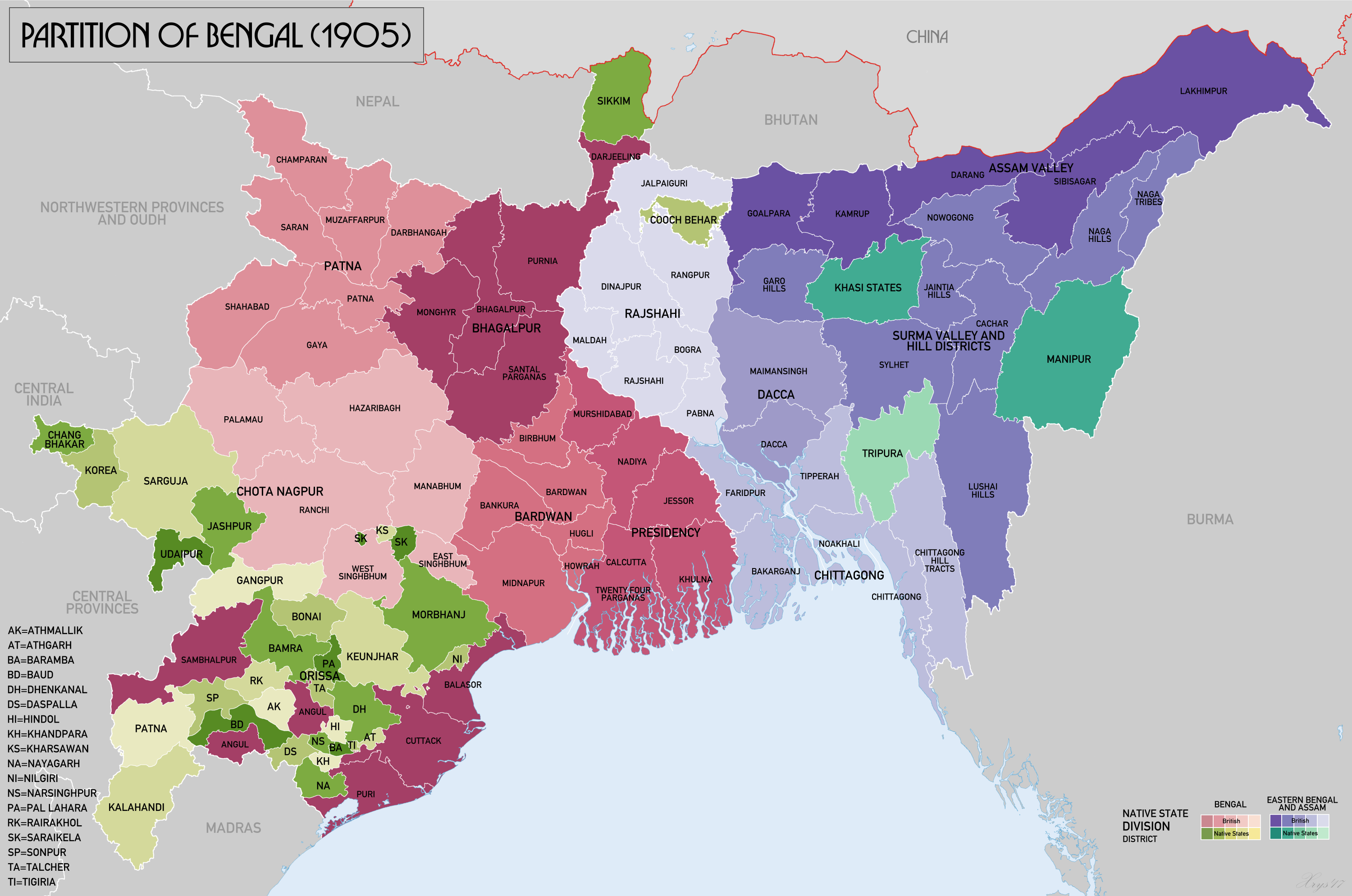 | ৩,০০০ × ১,৯৮৯ (১.১৯ মেগাবাইট) | smartcommons>XrysD | Added missing labels for Ranchi and Palamau districts. Removed Lohardaga label. |
ফাইলের ব্যবহার
এই ফাইল ব্যবহার করে এমন কোনো পাতা নেই।
