চিত্র:Boundary lines of British Guiana 1896.jpg

মূল ফাইল (৯২৫ × ১,৩৮৮ পিক্সেল, ফাইলের আকার: ৩৭২ কিলোবাইট, এমআইএমই ধরন: image/jpeg)

সারাংশ
Boundary lines of British Guiana on the map of Scottisch Geographical Magazine, 1896 (page 88) It shows a) The extreme boundary claimed by the United Kingdom (into present day Venezuela in heavy black line); b) Roughly the current modern day boundary; and c) a variation of the current boundary; and d) The extreme boundary clamed by Venezuela (into Present day Guyana).
Map by the Edinburgh Geographical Institute & John George Bartholomew - "Cartographer to the King"(1860-1920)
লাইসেন্স প্রদান
| Public domainPublic domainfalsefalse |

|
এই কর্মটি এর উৎস দেশে পাবলিক ডোমেইনে রয়েছে এবং অন্যান্য দেশ ও অঞ্চলে যেখানে কপিরাটের সময়সীমা হচ্ছে লেখকের জীবন যোগ ৭০ বছর বা তাঁর কম।  You must also include a United States public domain tag to indicate why this work is in the public domain in the United States. You must also include a United States public domain tag to indicate why this work is in the public domain in the United States.
|
| এই ফাইলটি কপিরাইট আইনের আওতায় জানা সকল বাধানিষেধ মুক্ত বলে চিহ্নিত হয়েছে, যার মধ্যে সম্পর্কিত সকল স্বত্ব ও নেইবারিং সত্ত্ব সংযুক্ত। | |
https://creativecommons.org/publicdomain/mark/1.0/PDMCreative Commons Public Domain Mark 1.0falsefalse
ক্যাপশন
ফাইলের ইতিহাস
যেকোনো তারিখ/সময়ে ক্লিক করে দেখুন ফাইলটি তখন কী অবস্থায় ছিল।
| তারিখ/সময় | সংক্ষেপচিত্র | মাত্রা | ব্যবহারকারী | মন্তব্য | |
|---|---|---|---|---|---|
| বর্তমান | ০১:০৮, ১ মার্চ ২০০৬ | 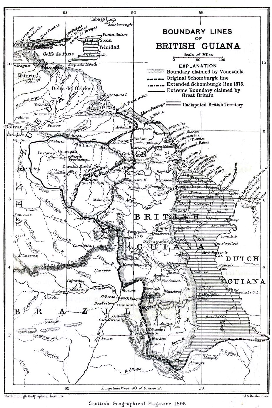 | ৯২৫ × ১,৩৮৮ (৩৭২ কিলোবাইট) | smartcommons>Julo | Boundary lines of British Guiana on the map of ''Scottisch Geographical Magazine'', 1896 (page 88) {{PD-old}} Category:Maps of Guyana |
ফাইলের ব্যবহার
এই ফাইল ব্যবহার করে এমন কোনো পাতা নেই।
