চিত্র:British Decolonisation in Africa.png

এই প্রাকদর্শনের আকার: ২২০ × ২২০ পিক্সেল। অন্যান্য আকারসমূহ: ২৪০ × ২৪০ পিক্সেল | ২,০০০ × ২,০০০ পিক্সেল।
মূল ফাইল (২,০০০ × ২,০০০ পিক্সেল, ফাইলের আকার: ৪০৬ কিলোবাইট, এমআইএমই ধরন: image/png)

সারাংশ

|
This historical map image could be re-created using vector graphics as a SVG file. This has several advantages; see Commons:Media for cleanup for more information. If a SVG form of this image is available, please upload it and afterwards replace this template with
{{vector version available|new image name}}.It is recommended to name the SVG file “British Decolonisation in Africa.svg”—then the template Vector version available (or Vva) does not need the new image name parameter. |
| বিবরণBritish Decolonisation in Africa.png |
English: Map of British decolonisation in Africa. The beige areas were under British military administration after WW2. The different shades of pink refer to the stages of decolonization according to decades. |
| তারিখ | ১ নভেম্বর ২০০৮ (মূল আপলোডের তারিখ) |
| উৎস |
Transferred from en.wikipedia; transfer was stated to be made by User:Hejsa. Blank map from File:BlankMap-World3.svg . Original text:
|
| লেখক | The Red Hat of Pat Ferrick t (log) |
| অনুমতি (এ ফাইলের পুনঃব্যবহার) |
Released into the public domain (by the author). |


লাইসেন্স প্রদান
| Public domainPublic domainfalsefalse |

|
এই কাজের প্রণেতা The Red Hat of Pat Ferrick ইংরেজি উইকিমিডিয়া কমন্স প্রকল্পের কাজটি পাবলিক ডোমেইনে প্রকাশ করেছেন। এটি বিশ্বব্যাপী প্রযোজ্য হবে। যে ক্ষেত্রে এটি আইনত সম্ভব নয়: |
মূল আপলোড লগ
মূল বিবরণ পাতাটি এখানে ছিল। নিম্নলিখিত সকল ব্যবহারকারীর নাম en.wikipedia-এ উল্লেখ করা ছিল।

- 2008-11-02 00:56 The Red Hat of Pat Ferrick 757×785× (171674 bytes) {{Information |Description=Map of British decolonisation in Africa. |Source=I created this work entirely by myself. |Date=1 November 2008 |Author=~~~ |other_versions= }}
ক্যাপশন
এই ফাইলটি কী উপস্থাপন করছে তার এক লাইন ব্যাখ্যা যোগ করুন
Decolonization of British Imperial Africa
Britanya İmperiyasını Afrika dekolonizayası
Descolonização da África britânica
ফাইলের ইতিহাস
যেকোনো তারিখ/সময়ে ক্লিক করে দেখুন ফাইলটি তখন কী অবস্থায় ছিল।
| তারিখ/সময় | সংক্ষেপচিত্র | মাত্রা | ব্যবহারকারী | মন্তব্য | |
|---|---|---|---|---|---|
| বর্তমান | ১৪:১৯, ৮ নভেম্বর ২০২১ | 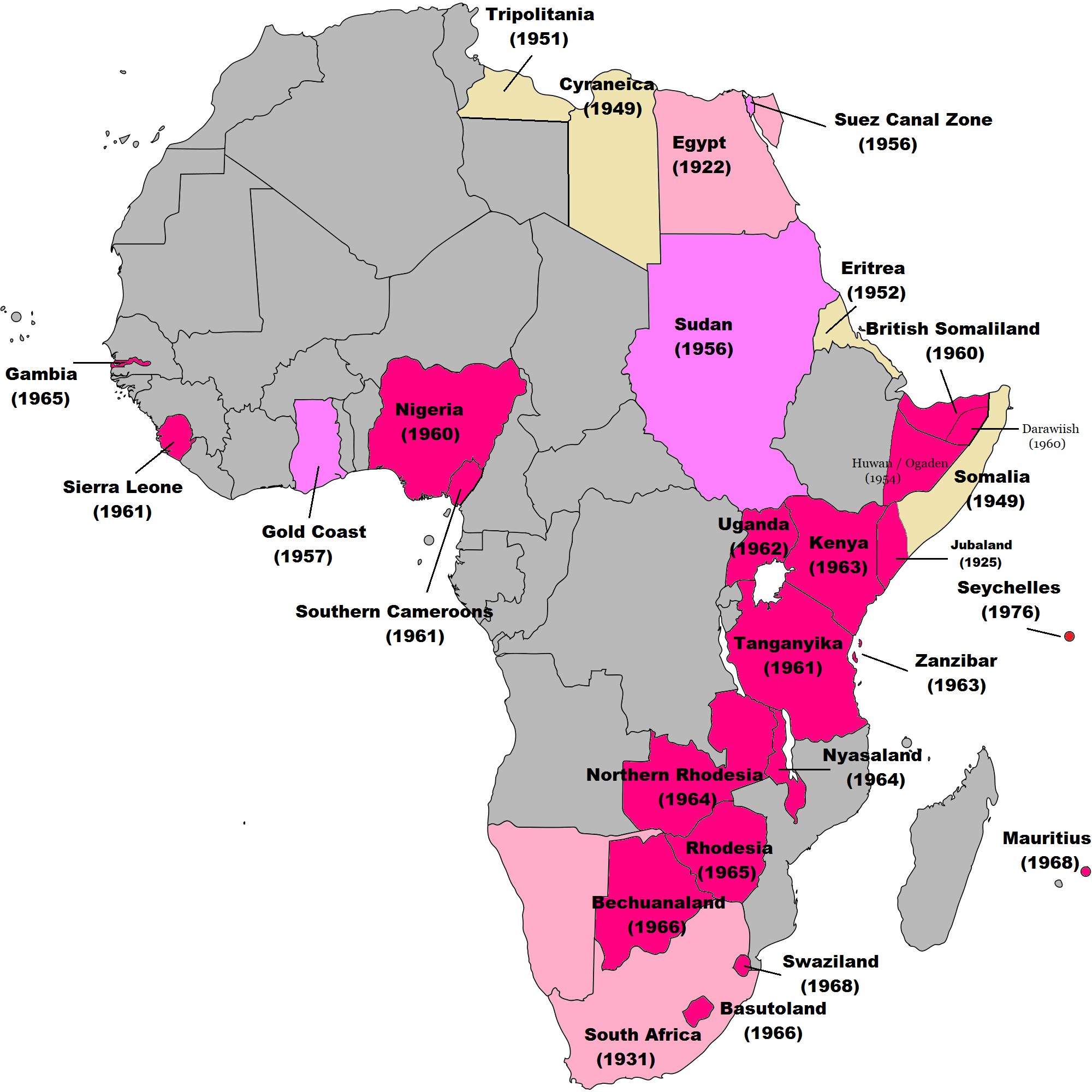 | ২,০০০ × ২,০০০ (৪০৬ কিলোবাইট) | smartcommons>Randomastwritter | ogaden |
ফাইলের ব্যবহার
এই ফাইল ব্যবহার করে এমন কোনো পাতা নেই।
