চিত্র:Cantinomap redsea persiangulf.jpg

এই প্রাকদর্শনের আকার: ২২০ × ২০০ পিক্সেল। অন্যান্য আকারসমূহ: ২৬৪ × ২৪০ পিক্সেল | ৬৬৬ × ৬০৫ পিক্সেল।
মূল ফাইল (৬৬৬ × ৬০৫ পিক্সেল, ফাইলের আকার: ৩১৮ কিলোবাইট, এমআইএমই ধরন: image/jpeg)
| বিবরণCantinomap redsea persiangulf.jpg | Enlarged detail showing Red Sea and Persian Gulf as viewed in 1502 in the Cantino World Map. Most important manuscript map surviving from the early Age of Discovery, the Cantino World Map is named for Alberto Cantino, an Italian diplomatic agent in Lisbon who obtained it in 1502 for the Duke of Ferrara. It incorporates extensive new geographical information based on four series of voyages: Columbus to the Caribbean, Pedro Álvarez Cabral to Brazil, Vasco de Gama followed by Cabral to eastern Africa and India, and the brothers Corte-Real to Greenland and Newfoundland. Except for Columbus, all had sailed under the Portuguese flag. |
| তারিখ | (UTC) |
| উৎস | |
| লেখক |
|
 |
এটি একটি পুনঃসম্পাদিত চিত্র, যার মানে হল যে এটি ডিজিটালরূপে এটির মূল সংস্করণ থেকে পরিবর্তন করা হয়েছে। পরিবর্তন: zoom in of Cantino map: the Red sea and Persian Golf। আসলটি দেখা যাবে এখানে: CantinoPlanisphere.png।
|
|
This is a faithful photographic reproduction of a two-dimensional, public domain work of art. The work of art itself is in the public domain for the following reason:
The official position taken by the Wikimedia Foundation is that "faithful reproductions of two-dimensional public domain works of art are public domain".
This photographic reproduction is therefore also considered to be in the public domain in the United States. In other jurisdictions, re-use of this content may be restricted; see Reuse of PD-Art photographs for details. | |||||


মূল আপলোড লগ
This image is a derivative work of the following images:
- File:CantinoPlanisphere.png licensed with PD-Art, PD-old
- 2007-07-01T05:35:29Z Tdmthomas 3528x1656 (12458523 Bytes) {{Information |Description=The most important manuscript map surviving from the early Age of Discovery, the Cantino World Map is named for Alberto Cantino, an Italian diplomatic agent in Lisbon who obtained it in 1502 for the
Uploaded with derivativeFX
ক্যাপশন
এই ফাইলটি কী উপস্থাপন করছে তার এক লাইন ব্যাখ্যা যোগ করুন
ফাইলের ইতিহাস
যেকোনো তারিখ/সময়ে ক্লিক করে দেখুন ফাইলটি তখন কী অবস্থায় ছিল।
| তারিখ/সময় | সংক্ষেপচিত্র | মাত্রা | ব্যবহারকারী | মন্তব্য | |
|---|---|---|---|---|---|
| বর্তমান | ১৯:০৯, ১২ ডিসেম্বর ২০০৯ | 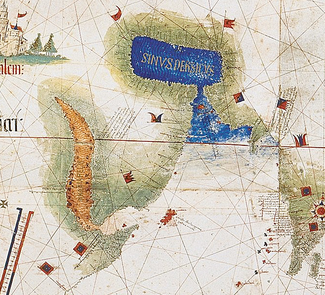 | ৬৬৬ × ৬০৫ (৩১৮ কিলোবাইট) | smartcommons>Uxbona | {{Information |Description= Enlarged detail showing Red Sea and Persian Gulf as viewed in 1502 in the Cantino World Map. Most important manuscript map surviving from the early Age of Discovery, the Cantino World Map is named for Alberto Cantino, an Italia |
ফাইলের ব্যবহার
এই ফাইল ব্যবহার করে এমন কোনো পাতা নেই।
