চিত্র:Colonisation 1800.png

মূল ফাইল (১,৪২৫ × ৬২৫ পিক্সেল, ফাইলের আকার: ৪২ কিলোবাইট, এমআইএমই ধরন: image/png)
সারাংশ
| বিবরণColonisation 1800.png |
English: Colonial empires in 1800 Français : Empires coloniaux en 1800 Español: Imperios coloniales en 1800 Português: Impérios Coloniais em 1800
|
||||||||||||||||
| তারিখ | |||||||||||||||||
| উৎস | নিজের কাজ | ||||||||||||||||
| লেখক | Jluisrs | ||||||||||||||||
| অনুমতি (এ ফাইলের পুনঃব্যবহার) |
|
||||||||||||||||


.jpg)


._LOC_2001620596.jpg)


|
File:Colonial empires in 1800.svg এই ফাইলের একটি ভেক্টর সংস্করণ। যখন উচ্চতর তখন এটি এই রাস্টার চিত্রের জায়গায় ব্যবহার করা উচিত।
File:Colonisation 1800.png → File:Colonial empires in 1800.svg
ভেক্টর গ্রাফিক্স সম্পর্কে আরও তথ্যের জন্য, কমন্স এসভিজিতে রূপান্তর সম্পর্কে পড়ুন। সেখানে মিডিয়াউইকির এসভিজি চিত্র সমর্থন সম্পর্কে তথ্য রয়েছে। |
 |
| Annotations InfoField | This image is annotated: View the annotations at Commons |

The extent of British influence in New Zealand in 1800 was the existence of whaling ships and flax traders. Americans and French were also present in New Zealand waters. Missionary presence had not even been established yet, and gun traders weren't significant until about the time of the Musket Wars. New Zealand not British prior to 1840 annexation. However, under the 1788 amended charter of the New South Wales colony, islands adjacent to that region of Australia within the bounds of 10°37'S and 43°39'S are included under it. This includes all but the Southern half of South Island. Recognizing this might be like recognizing the Treaty of Tordesillas on this map, but there is some basis for most of New Zealand being counted as a British colony on this map. (See: http://en.wikipedia.org/wiki/History_of_new_zealand#British_sovereignty, http://en.wikipedia.org/wiki/43rd_parallel_south) Nanib (talk) 19:08, 8 September 2011 (UTC)
Araucania and Patagonia not colonized or occupied by Europeans. Mapuche groups prevented Southward expansion by Spanish. Chile and Argentina began occupying the region from 1843-1902. http://en.wikipedia.org/wiki/Patagonia#Chilean_and_Argentine_expansion_.281843-1902.29
A Norwegian colony existed at Nuuk from 1728. It became Danish in 1814. http://en.wikipedia.org/wiki/Nuuk
Omanese colonies on East African coast from 1698. It might be good to include this, but if the focus of this map is European-related colonies, then it shouldn't be. http://en.wikipedia.org/wiki/Oman#Oman_and_East_Africa
British may have had further holdings in Bengal. http://en.wikipedia.org/wiki/Company_rule_in_India#Expansion_and_territory
Zeila, in Western Somililand, ruled by Ottomans from 1548. http://en.wikipedia.org/wiki/History_of_Somaliland#Ottoman_Somaliland
Dutch Gold Coast from 1598. It might be too small to show. http://en.wikipedia.org/wiki/Dutch_Gold_Coast
The Spanish East Indies in the Pacific. After its discovery in 1521, all of Micronesia was included in the Captaincy General of the Philippines of Spain, but his claim effectively began in 1885, the year in which the Micronesia partitioned between Spain and Germany.
In 1800 the French occupation lasted (http://en.wikipedia.org/wiki/French_campaign_in_Egypt_and_Syria)
ক্যাপশন
ফাইলের ইতিহাস
যেকোনো তারিখ/সময়ে ক্লিক করে দেখুন ফাইলটি তখন কী অবস্থায় ছিল।
| তারিখ/সময় | সংক্ষেপচিত্র | মাত্রা | ব্যবহারকারী | মন্তব্য | |
|---|---|---|---|---|---|
| বর্তমান | ০০:৫৮, ২ মে ২০১৬ | 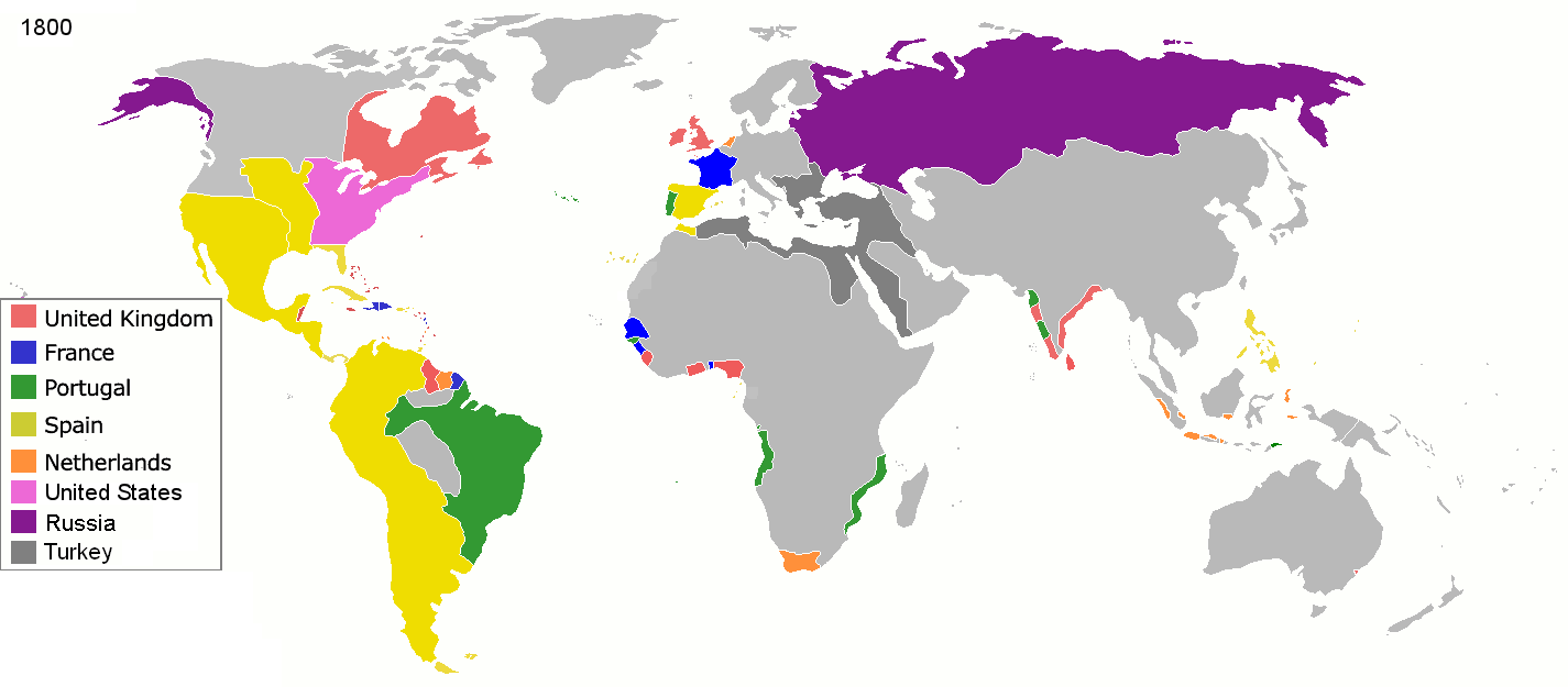 | ১,৪২৫ × ৬২৫ (৪২ কিলোবাইট) | smartcommons>Mega-light | Dominican Republic was a French colonia between 1795 and 1808 through Treaty of Basilea. |
ফাইলের ব্যবহার
এই ফাইল ব্যবহার করে এমন কোনো পাতা নেই।
