চিত্র:Gedrosia-Map-Route-of-Alexander-1823-Lucas.png

এই প্রাকদর্শনের আকার: ২২০ × ২২১ পিক্সেল। অন্যান্য আকারসমূহ: ২৩৯ × ২৪০ পিক্সেল | ৬৫৬ × ৬৬০ পিক্সেল।
মূল ফাইল (৬৫৬ × ৬৬০ পিক্সেল, ফাইলের আকার: ৮৮১ কিলোবাইট, এমআইএমই ধরন: image/png)
সারাংশ
| বিবরণGedrosia-Map-Route-of-Alexander-1823-Lucas.png |
Map of the route of Alexander the Great in South Asia,
|
||||||||||||||||||||
| তারিখ | |||||||||||||||||||||
| উৎস | scanned from Plate 12 of A general atlas containing distinct maps of all the known countries in the world by Fielding Lucas | ||||||||||||||||||||
| লেখক |
engraved by J. Yeager; published by
creator QS:P170,Q1411601 |
||||||||||||||||||||
| অনুমতি (এ ফাইলের পুনঃব্যবহার) |
Public Domain | ||||||||||||||||||||


লাইসেন্স প্রদান
|
This is a faithful photographic reproduction of a two-dimensional, public domain work of art. The work of art itself is in the public domain for the following reason:
The official position taken by the Wikimedia Foundation is that "faithful reproductions of two-dimensional public domain works of art are public domain".
This photographic reproduction is therefore also considered to be in the public domain in the United States. In other jurisdictions, re-use of this content may be restricted; see Reuse of PD-Art photographs for details. | |||||


ক্যাপশন
এই ফাইলটি কী উপস্থাপন করছে তার এক লাইন ব্যাখ্যা যোগ করুন
ফাইলের ইতিহাস
যেকোনো তারিখ/সময়ে ক্লিক করে দেখুন ফাইলটি তখন কী অবস্থায় ছিল।
| তারিখ/সময় | সংক্ষেপচিত্র | মাত্রা | ব্যবহারকারী | মন্তব্য | |
|---|---|---|---|---|---|
| বর্তমান | ২৩:২১, ২৯ নভেম্বর ২০০৭ | 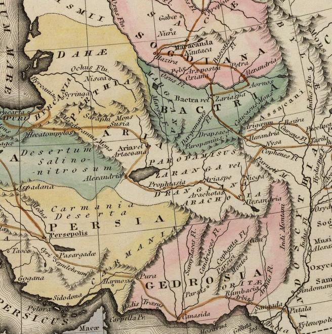 | ৬৫৬ × ৬৬০ (৮৮১ কিলোবাইট) | smartcommons>Bejnar | {{Information |Description=Map of the route of Alexander the Great through Gedrosia, Bactria, and Sogdiana part of a map entitled "Alexandri Magni Itinera" based upon Melish (1815) ''Atlas of Ancient Geography'' |Source= scanned from Plate 12 of ''A gener |
ফাইলের ব্যবহার
এই ফাইল ব্যবহার করে এমন কোনো পাতা নেই।
