চিত্র:Kargil.map.gif

এই প্রাকদর্শনের আকার: ২২০ × ২০৪ পিক্সেল। অন্যান্য আকারসমূহ: ২৫৯ × ২৪০ পিক্সেল | ৪২৮ × ৩৯৬ পিক্সেল।
মূল ফাইল (৪২৮ × ৩৯৬ পিক্সেল, ফাইলের আকার: ১১ কিলোবাইট, এমআইএমই ধরন: image/gif)


|
This locator map image could be re-created using vector graphics as a SVG file. This has several advantages; see Commons:Media for cleanup for more information. If a SVG form of this image is available, please upload it and afterwards replace this template with
{{vector version available|new image name}}.It is recommended to name the SVG file “Kargil.map.svg”—then the template Vector version available (or Vva) does not need the new image name parameter. |
| Public domainPublic domainfalsefalse |

|
This file is a work of a sailor or employee of the U.S. Navy, taken or made as part of that person's official duties. As a work of the U.S. federal government, it is in the public domain in the United States.
|
 |
| এই ফাইলটি কপিরাইট আইনের আওতায় জানা সকল বাধানিষেধ মুক্ত বলে চিহ্নিত হয়েছে, যার মধ্যে সম্পর্কিত সকল স্বত্ব ও নেইবারিং সত্ত্ব সংযুক্ত। | ||
https://creativecommons.org/publicdomain/mark/1.0/PDMCreative Commons Public Domain Mark 1.0falsefalse
Source: http://www.ccc.nps.navy.mil/research/kargil/index.asp আর্কাইভকৃত অনুলিপি at the Wayback Machine
Geo-political location of Kargil.
derivative works
এই ফাইলের উপজাত কর্মসমূহ:


ক্যাপশন
এই ফাইলটি কী উপস্থাপন করছে তার এক লাইন ব্যাখ্যা যোগ করুন
Line of control
ফাইলের ইতিহাস
যেকোনো তারিখ/সময়ে ক্লিক করে দেখুন ফাইলটি তখন কী অবস্থায় ছিল।
| তারিখ/সময় | সংক্ষেপচিত্র | মাত্রা | ব্যবহারকারী | মন্তব্য | |
|---|---|---|---|---|---|
| বর্তমান | ১৩:৩৯, ১৯ এপ্রিল ২০০৭ | 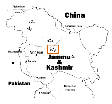 | ৪২৮ × ৩৯৬ (১১ কিলোবাইট) | smartcommons>A3A3A3A | {{PD-USGov-Military-Navy}} Source: http://www.ccc.nps.navy.mil/research/kargil/index.asp Geo-political location of Kargil. |
ফাইলের ব্যবহার
নিম্নলিখিত পাতাটি এই ফাইল ব্যবহার করে:
