চিত্র:Lucas gusher.jpg

এই প্রাকদর্শনের আকার: ২২০ × ২৯৯ পিক্সেল। অন্যান্য আকারসমূহ: ১৭৬ × ২৪০ পিক্সেল | ৪,৪৫৯ × ৬,০৬৭ পিক্সেল।
মূল ফাইল (৪,৪৫৯ × ৬,০৬৭ পিক্সেল, ফাইলের আকার: ১২.১৮ মেগাবাইট, এমআইএমই ধরন: image/jpeg)


|
This is an image of a place or building that is listed on the National Register of Historic Places in the United States of America. Its reference number is 66000818 (Wikidata). |
সারাংশ
| বিবরণLucas gusher.jpg |
English: The Lucas Gusher at Spindletop Hill, South of Beaumont, Texas, United States |
| তারিখ | |
| উৎস | Original photo by John Trost. w:en:Image:Lucas_gusher.jpg by Nv8200p, 4/12/2006 16:29 (UTC) |
| লেখক | Note: Image is available at [1] on the Paleontological Research Institution web site. The site credits the American Petroleum Institute; however, a Texas roadside historical marker credits John Trost (June 24, 1868 - August 4, 1944) [2] [3] |

| বস্তুর অবস্থান |  | এটি এবং অন্যান্য ছবি তাদের অবস্থানের উপর: ওপেনস্ট্রিটম্যাপ |  30.020000; -94.075278 30.020000; -94.075278 |
|---|

লাইসেন্স প্রদান
| Public domainPublic domainfalsefalse |
 |
This media file is in the public domain in the United States. This applies to U.S. works where the copyright has expired, often because its first publication occurred prior to January 1, 1931, and if not then due to lack of notice or renewal. See this page for further explanation.
|
 |
 |
ক্যাপশন
এই ফাইলটি কী উপস্থাপন করছে তার এক লাইন ব্যাখ্যা যোগ করুন
Lucas Gusher at Spindletop Hill, South of Beaumont, Texas, United States
ফাইলের ইতিহাস
যেকোনো তারিখ/সময়ে ক্লিক করে দেখুন ফাইলটি তখন কী অবস্থায় ছিল।
| তারিখ/সময় | সংক্ষেপচিত্র | মাত্রা | ব্যবহারকারী | মন্তব্য | |
|---|---|---|---|---|---|
| বর্তমান | ০৭:২১, ৭ অক্টোবর ২০২৫ | 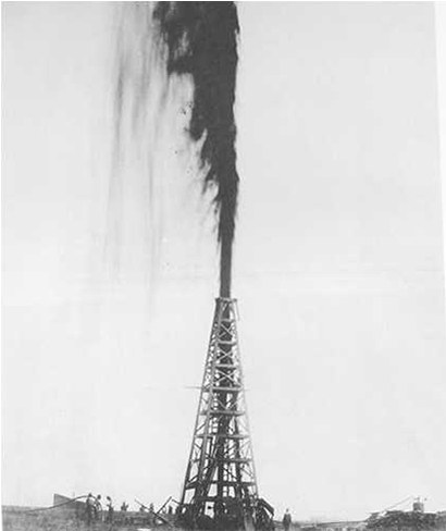 | ৪,৪৫৯ × ৬,০৬৭ (১২.১৮ মেগাবাইট) | smartcommons>JayCubby | c:User:Rillke/bigChunkedUpload.js: partways restore |
ফাইলের ব্যবহার
এই ফাইল ব্যবহার করে এমন কোনো পাতা নেই।
