চিত্র:Map Iran 1900-en.png

এই প্রাকদর্শনের আকার: ২২০ × ১৮৩ পিক্সেল। অন্যান্য আকারসমূহ: ২৮৯ × ২৪০ পিক্সেল | ১,০৯৬ × ৯১১ পিক্সেল।
মূল ফাইল (১,০৯৬ × ৯১১ পিক্সেল, ফাইলের আকার: ৩৫২ কিলোবাইট, এমআইএমই ধরন: image/png)


|
This historical map image could be re-created using vector graphics as a SVG file. This has several advantages; see Commons:Media for cleanup for more information. If a SVG form of this image is available, please upload it and afterwards replace this template with
{{vector version available|new image name}}.It is recommended to name the SVG file “Map Iran 1900-en.svg”—then the template Vector version available (or Vva) does not need the new image name parameter. |
সারাংশ
| বিবরণMap Iran 1900-en.png |
English: Iran circa 1900. Inspired by the Historical Atlas by Georges Duby, p. 211, map C, this map was made by Fabienkhan on 25 September 2006 using Inkscape and GIMP.
Français : L’Iran vers 1900. Inspirée par l’Atlas historique de Georges Duby, p. 211, carte C, cette carte a été conçue par Fabienkhan le 25 septembre 2006 à l’aide d’Inkscape et de GIMP. |
| তারিখ | ২৪ সেপ্টেম্বর ২০০৬ (মূল আপলোডের তারিখ) |
| উৎস | নিজের কাজ |
| লেখক | Fabienkhan |
| অন্যান্য সংস্করণ | See also the French version: File:Map_Iran_1900-fr.png |

লাইসেন্স প্রদান
আমি, এই কাজের স্বত্বাধিকারী, এতদ্দ্বারা আমি এই কাজকে নিম্ন বর্ণিত লাইসেন্সের আওতায় প্রকাশ করলাম:


এই ফাইলটি ক্রিয়েটিভ কমন্স অ্যাট্রিবিউশন-শেয়ার অ্যালাইক ২.৫ জেনেরিক, ২.০ জেনেরিক এবং ১.০ জেনেরিক লাইসেন্সের আওতায় লাইসেন্সকৃত।
- আপনি স্বাধীনভাবে:
- বণ্টন করতে পারেন – এ কাজটি অনুলিপি, বিতরণ এবং প্রেরণ করতে পারেন
- পুনঃমিশ্রণ করতে পারেন – কাজটি অভিযোজন করতে পারেন
- নিম্নের শর্তাবলীর ভিত্তিতে:
- স্বীকৃতিপ্রদান – আপনাকে অবশ্যই যথাযথ স্বীকৃতি প্রদান করতে হবে, লাইসেন্সের একটি লিঙ্ক সরবরাহ করতে হবে এবং কোনো পরিবর্তন হয়েছে কিনা তা নির্দেশ করতে হবে। আপনি যেকোনো যুক্তিসঙ্গত পদ্ধতিতে এটি করতে পারেন। কিন্তু এমন ভাবে নয়, যাতে প্রকাশ পায় যে লাইসেন্সধারী আপনাকে বা আপনার এই ব্যবহারের জন্য অনুমোদন দিয়েছে।
- একইভাবে বণ্টন – আপনি যদি কাজটি পুনঃমিশ্রণ, রুপান্তর, বা এর ওপর ভিত্তি করে নতুন সৃষ্টিকর্ম তৈরি করেন, তবে আপনাকে অবশ্যই আপনার অবদান একই লাইসেন্স বা একই রকমের লাইসেন্সের আওতায় বিতরণ করতে হবে।

Note:
 Inspired by the Historical Atlas by Georges Duby, p. 211, map C, this map was made by Fabienkhan on 25 September 2006 with Inkscape and GIMP.
 Inspiré par l’Atlas historique de Georges Duby, p. 211, carte C, cette carte a été conçue par Fabienkhan le 25 septembre 2006 à l’aide d’Inkscape et de GIMP.
Description:
L’Iran vers 1900
Iran circa 1900
ক্যাপশন
এই ফাইলটি কী উপস্থাপন করছে তার এক লাইন ব্যাখ্যা যোগ করুন
ফাইলের ইতিহাস
যেকোনো তারিখ/সময়ে ক্লিক করে দেখুন ফাইলটি তখন কী অবস্থায় ছিল।
| তারিখ/সময় | সংক্ষেপচিত্র | মাত্রা | ব্যবহারকারী | মন্তব্য | |
|---|---|---|---|---|---|
| বর্তমান | ২৩:১০, ৬ আগস্ট ২০১৭ | 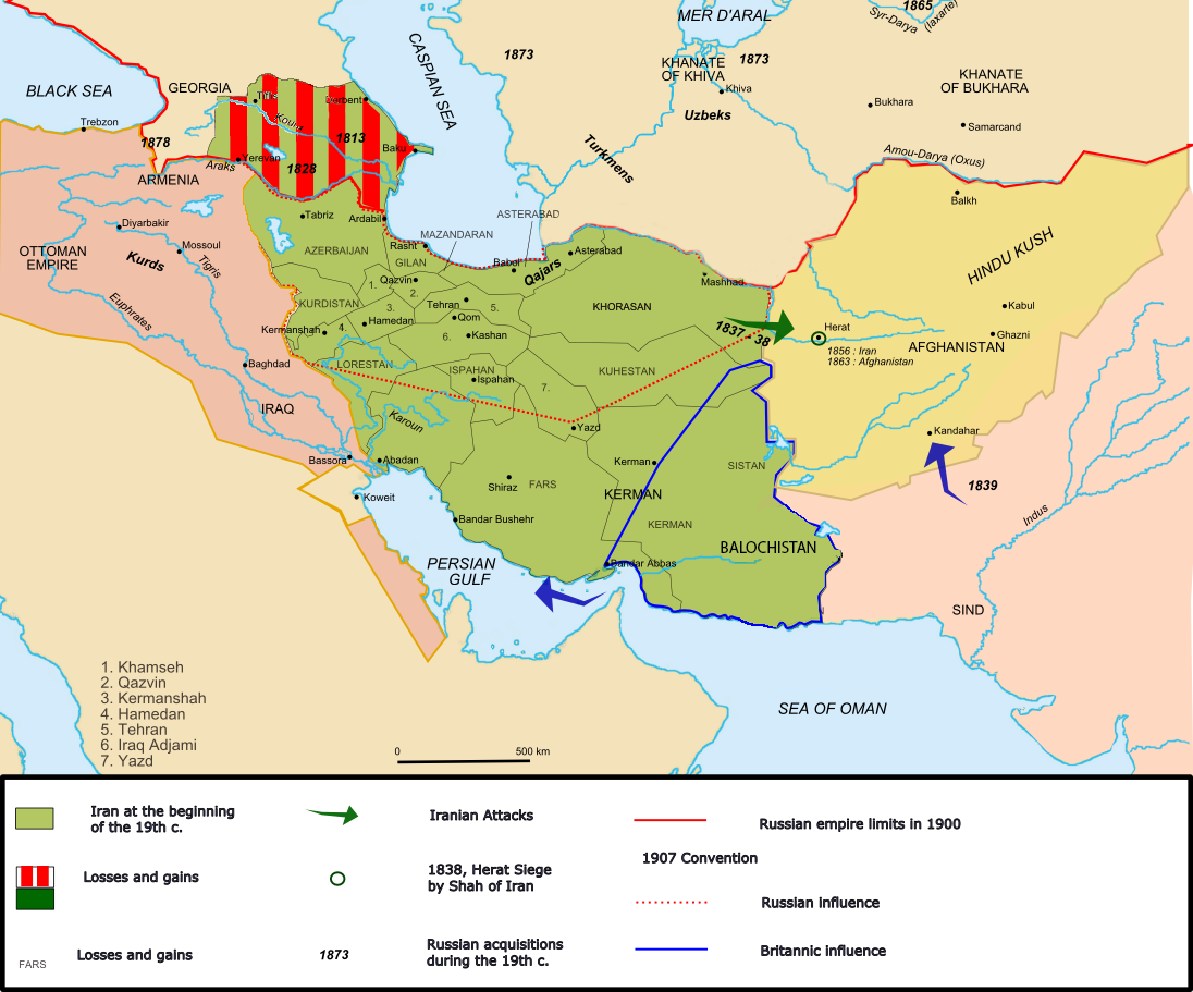 | ১,০৯৬ × ৯১১ (৩৫২ কিলোবাইট) | smartcommons>Oganesson007 | Added Kingdom of Kartli-Kakheti, deleted modern day Turkmenistan, which was never under Qajar's control. |
ফাইলের ব্যবহার
এই ফাইল ব্যবহার করে এমন কোনো পাতা নেই।
