চিত্র:Mauryan Empire Map.gif

এই প্রাকদর্শনের আকার: ২২০ × ১৮৫ পিক্সেল। অন্যান্য আকারসমূহ: ২৮৫ × ২৪০ পিক্সেল | ৪০০ × ৩৩৭ পিক্সেল।
মূল ফাইল (৪০০ × ৩৩৭ পিক্সেল, ফাইলের আকার: ১১ কিলোবাইট, এমআইএমই ধরন: image/gif)

|
This map has been uploaded by Electionworld from en.wikipedia.org to enable the  Wikimedia Atlas of the World . Original uploader to en.wikipedia.org was Vastu, known as Vastu at en.wikipedia.org. Electionworld is not the creator of this map. Licensing information is below. Wikimedia Atlas of the World . Original uploader to en.wikipedia.org was Vastu, known as Vastu at en.wikipedia.org. Electionworld is not the creator of this map. Licensing information is below.
|
সারাংশ
| বিবরণMauryan Empire Map.gif |
English: A political map of the Mauryan Empire, including notable cities, such as the capital Pataliputra, and site of the Buddha's enlightenment. this mapis really hard to find txd Green blue represents notable rivers, black represetns modern political borders, and brown represents the border of South Asia. Pataliputra, Sanchi, Ujjain, Bodh Gaya, [[:w:Taxila]|Taxila]]], Mathura, Indraprastha and Pattala Kaushambi, [pryag] are shown. |
|||
| তারিখ | File was made on 03 August 2006, using Paint (software). | |||
| উৎস | Based upon common political maps of the Mauryan Empire, created from this template: Image:Marathas.GIF | |||
| লেখক | ||||
| অন্যান্য সংস্করণ |
|


লাইসেন্স প্রদান
| Public domainPublic domainfalsefalse |

|
এই কাজের প্রণেতা Vastu কাজটি পাবলিক ডোমেইনে প্রকাশ করেছেন। এটি বিশ্বব্যাপী প্রযোজ্য হবে। কিছু দেশে এটি আইনত সিদ্ধ নাও হতে পারে, যদি তাই হয়: |
ক্যাপশন
এই ফাইলটি কী উপস্থাপন করছে তার এক লাইন ব্যাখ্যা যোগ করুন
ফাইলের ইতিহাস
যেকোনো তারিখ/সময়ে ক্লিক করে দেখুন ফাইলটি তখন কী অবস্থায় ছিল।
| তারিখ/সময় | সংক্ষেপচিত্র | মাত্রা | ব্যবহারকারী | মন্তব্য | |
|---|---|---|---|---|---|
| বর্তমান | ০৫:৪৬, ২৫ মার্চ ২০১৬ | 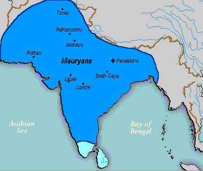 | ৪০০ × ৩৩৭ (১১ কিলোবাইট) | smartcommons>LouisAragon | rv, changes made by a banned user. |
ফাইলের ব্যবহার
নিম্নলিখিত পাতাটি এই ফাইল ব্যবহার করে:
