চিত্র:Mexico city ESA348919.jpg

মূল ফাইল (১,৯২০ × ১,৭৮৭ পিক্সেল, ফাইলের আকার: ৫.৭৩ মেগাবাইট, এমআইএমই ধরন: image/jpeg)
সারাংশ
| বিবরণMexico city ESA348919.jpg |
English: This natural-colour Sentinel-2A image features Mexico City and surroundings.
Home to nearly nine million people, Mexico City is the densely populated, high-altitude capital of Mexico. Sentinel’s optical camera clearly shows the difference between the densely built city centre and the vast surrounding vegetation. The brownish-grey patch in the right corner of the central part of the image is a flat area with some agriculture, criss-crossed by canals. Mexico International Airport is also visible, and further along the dark green rectangle is Lake Nabor Carrillo. This is a reservoir, encompassing more than 14 163 ha, which is 41 times larger than New York’s Central Park. Mexico City sits in the Valley of Mexico, also called the Valley of Anáhuac, a large valley in the high plateaus at the centre of Mexico, at an altitude of 2240 m. This valley is in the Trans-Mexican Volcanic Belt, which is at least 2200 m above sea level. Mountains and volcanoes surround it, with elevations reaching beyond 5000 m. The city rests mainly on the heavily saturated clay of what used to be Lake Texcoco. This soft base is collapsing through the over-extraction of groundwater, and the city has sunk as much as nine metres in some areas since the beginning of the 20th century. Clouds are scattered throughout the image, under which lie various national parks and some of the still-active volcanoes, such as Popocatépetl at 5426 m. Launched on 23 June, Sentinel-2A is a polar-orbiting, multispectral high-resolution imaging mission for land monitoring to provide images of vegetation, soil and water cover, inland waterways and coastal areas. While supplying our planet with such vital data, it can also deliver information for emergency services. Also featured on the Earth from Space video programme, this image was captured by Sentinel-2A on 6 August. |
| তারিখ | |
| উৎস | http://www.esa.int/spaceinimages/Images/2015/10/Mexico_city |
| লেখক | European Space Agency |
| অনুমতি (এ ফাইলের পুনঃব্যবহার) |
Copernicus Sentinel data (2015)/ESA,CC BY-SA 3.0 IGO |
| অন্যান্য সংস্করণ |
|
| Title InfoField | Mexico city |
| Set InfoField | Earth observation image of the week |
| System InfoField | Copernicus |
| Mission InfoField | Sentinel-2 |
| Location InfoField | Mexico |
| Activity InfoField | Observing the Earth |
| Keywords InfoField | City; Satellite image |


লাইসেন্স প্রদান


- আপনি স্বাধীনভাবে:
- বণ্টন করতে পারেন – এ কাজটি অনুলিপি, বিতরণ এবং প্রেরণ করতে পারেন
- পুনঃমিশ্রণ করতে পারেন – কাজটি অভিযোজন করতে পারেন
- নিম্নের শর্তাবলীর ভিত্তিতে:
- স্বীকৃতিপ্রদান – আপনাকে অবশ্যই যথাযথ স্বীকৃতি প্রদান করতে হবে, লাইসেন্সের একটি লিঙ্ক সরবরাহ করতে হবে এবং কোনো পরিবর্তন হয়েছে কিনা তা নির্দেশ করতে হবে। আপনি যেকোনো যুক্তিসঙ্গত পদ্ধতিতে এটি করতে পারেন। কিন্তু এমন ভাবে নয়, যাতে প্রকাশ পায় যে লাইসেন্সধারী আপনাকে বা আপনার এই ব্যবহারের জন্য অনুমোদন দিয়েছে।
- একইভাবে বণ্টন – আপনি যদি কাজটি পুনঃমিশ্রণ, রুপান্তর, বা এর ওপর ভিত্তি করে নতুন সৃষ্টিকর্ম তৈরি করেন, তবে আপনাকে অবশ্যই আপনার অবদান একই লাইসেন্স বা একই রকমের লাইসেন্সের আওতায় বিতরণ করতে হবে।


|
This image contains data from a satellite in the Copernicus Programme, such as Sentinel-1, Sentinel-2 or Sentinel-3. Attribution is required when using this image.
স্বীকৃতিপ্রদান: Contains modified Copernicus Sentinel data {{{year}}}
Attribution
The use of Copernicus Sentinel Data is regulated under EU law (Commission Delegated Regulation (EU) No 1159/2013 and Regulation (EU) No 377/2014). Relevant excerpts:
Free access shall be given to GMES dedicated data [...] made available through GMES dissemination platforms [...].
Access to GMES dedicated data [...] shall be given for the purpose of the following use in so far as it is lawful:
GMES dedicated data [...] may be used worldwide without limitations in time.
GMES dedicated data and GMES service information are provided to users without any express or implied warranty, including as regards quality and suitability for any purpose.
|
Attribution
ক্যাপশন
ফাইলের ইতিহাস
যেকোনো তারিখ/সময়ে ক্লিক করে দেখুন ফাইলটি তখন কী অবস্থায় ছিল।
| তারিখ/সময় | সংক্ষেপচিত্র | মাত্রা | ব্যবহারকারী | মন্তব্য | |
|---|---|---|---|---|---|
| বর্তমান | ০৫:১৬, ৮ মে ২০১৭ | 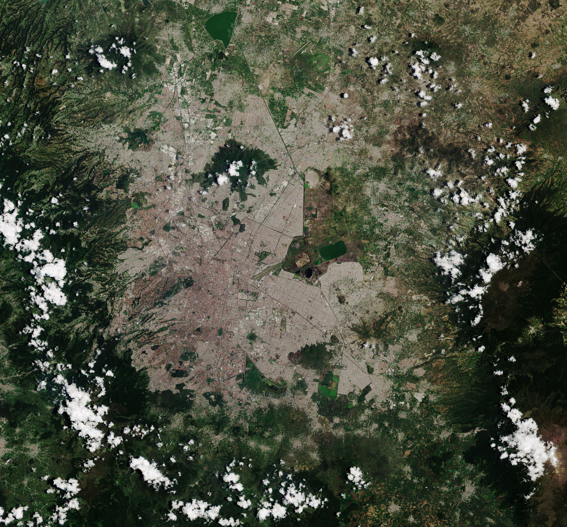 | ১,৯২০ × ১,৭৮৭ (৫.৭৩ মেগাবাইট) | smartcommons>Fæ | European Space Agency, Id 348919, http://www.esa.int/spaceinimages/Images/2015/10/Mexico_city, User:Fæ/Project_list/ESA |
ফাইলের ব্যবহার
এই ফাইল ব্যবহার করে এমন কোনো পাতা নেই।
