চিত্র:RzeczpospolitaII.png

এই প্রাকদর্শনের আকার: ২২০ × ২১১ পিক্সেল। অন্যান্য আকারসমূহ: ২৫০ × ২৪০ পিক্সেল | ১,১১২ × ১,০৬৯ পিক্সেল।
মূল ফাইল (১,১১২ × ১,০৬৯ পিক্সেল, ফাইলের আকার: ১৮৬ কিলোবাইট, এমআইএমই ধরন: image/png)

Second Polish Republic. Map based on File:Rzeczpospolita 1920.png.

This image is a derivative work of the following images:
- File:Rzeczpospolita_1920.png licensed with Cc-by-sa-3.0-migrated, GFDL
- 2009-12-05T08:35:28Z DJ Sturm 2000x1534 (369919 Bytes) Correct borders, improved Estonia
- 2009-08-16T14:37:51Z Halibutt 2000x1534 (349775 Bytes) Reverted to version as of 06:33, 8 May 2005 (don't do this. Modify the svg version instead, without those horrible colours and copy-paste leftovers)
- 2009-03-27T14:30:53Z DJ Sturm 2000x1534 (368552 Bytes) Fixed borders of Estonia, Latvia, Lithuania, Soviet Union and Germany, added some towns.
- 2005-05-08T06:33:43Z Halibutt 2000x1534 (349775 Bytes) Reverted to earlier revision
- 2005-05-07T21:41:55Z DeirYassin 2000x1534 (314976 Bytes) Corrected borders of Latvia and Russia, Estonia and Russia according to real interwar, rather than current, borders; the Lithuanian claim is shown.
- 2005-05-07T20:50:35Z DeirYassin 2000x1534 (314976 Bytes)
- 2005-05-07T20:47:17Z DeirYassin 2000x1534 (314976 Bytes)
- 2005-04-07T21:04:53Z Halibutt 2000x1534 (349775 Bytes) New additions: borders of Czechoslovakia corrected, new towns added, more changes to follow. Any suggestions?
- 2005-04-05T07:53:46Z Halibutt 2000x1534 (267139 Bytes) Newer version
- 2005-04-04T07:02:24Z Halibutt 2000x1534 (236688 Bytes) new version: Hungaro-Czechoslovak border corrected and town names added
- 2005-04-02T12:06:46Z Halibutt 2000x1534 (148548 Bytes) new version, colours added
- 2005-04-02T05:30:08Z Halibutt 2000x1534 (151894 Bytes) Early version of my map of Poland and Eastern Europe between 1918 and 1945. So far it features the borders and major towns and cities, as well as the frontlines of the [[Polish-Bolshevik War]]. The colours and fonts and other

|
এই নথি অনুলিপি, বিতরণ এবং/বা পরিবর্তন করার অনুমতি ফ্রি সফটওয়্যার ফাউন্ডেশন কর্তৃক প্রকাশিত গনু ফ্রি ডকুমেন্টেশন লাইসেন্স, সংস্করণ ১.২ বা তার পরবর্তী সংস্করণের আওতায় অনুমতিপ্রাপ্ত; যে কোনো রকম অনুচ্ছেদ পরিবর্তন, সম্মুখ-প্রচ্ছদের লেখা, পিছন-প্রচ্ছদের লেখা পরিবর্তন করা ছাড়াই। এই লাইসেন্সের একটি অনুলিপি গনু ফ্রি ডকুমেন্টেশন লাইসেন্স শিরোনামের অনুচ্ছেদে অন্তর্ভুক্ত করা আছে।http://www.gnu.org/copyleft/fdl.htmlGFDLGNU Free Documentation Licensetruetrue |
  
|
এই ফাইলটি ক্রিয়েটিভ কমন্স অ্যাট্রিবিউশন-শেয়ার অ্যালাইক ৩.০ আনপোর্টেড লাইসেন্সের আওতায় লাইসেন্সকৃত। | |
| ||
| এই লাইসেন্স ট্যাগটি জিএফডিএল লাইসেন্স হালনাগাদের অংশ হিসেবে এই ফাইলে সংযুক্ত হয়েছে।http://creativecommons.org/licenses/by-sa/3.0/CC BY-SA 3.0Creative Commons Attribution-Share Alike 3.0truetrue |
ক্যাপশন
এই ফাইলটি কী উপস্থাপন করছে তার এক লাইন ব্যাখ্যা যোগ করুন
Map of Poland in the period between WWI and WWII.
ফাইলের ইতিহাস
যেকোনো তারিখ/সময়ে ক্লিক করে দেখুন ফাইলটি তখন কী অবস্থায় ছিল।
| তারিখ/সময় | সংক্ষেপচিত্র | মাত্রা | ব্যবহারকারী | মন্তব্য | |
|---|---|---|---|---|---|
| বর্তমান | ১৩:৩০, ১১ সেপ্টেম্বর ২০১৬ | 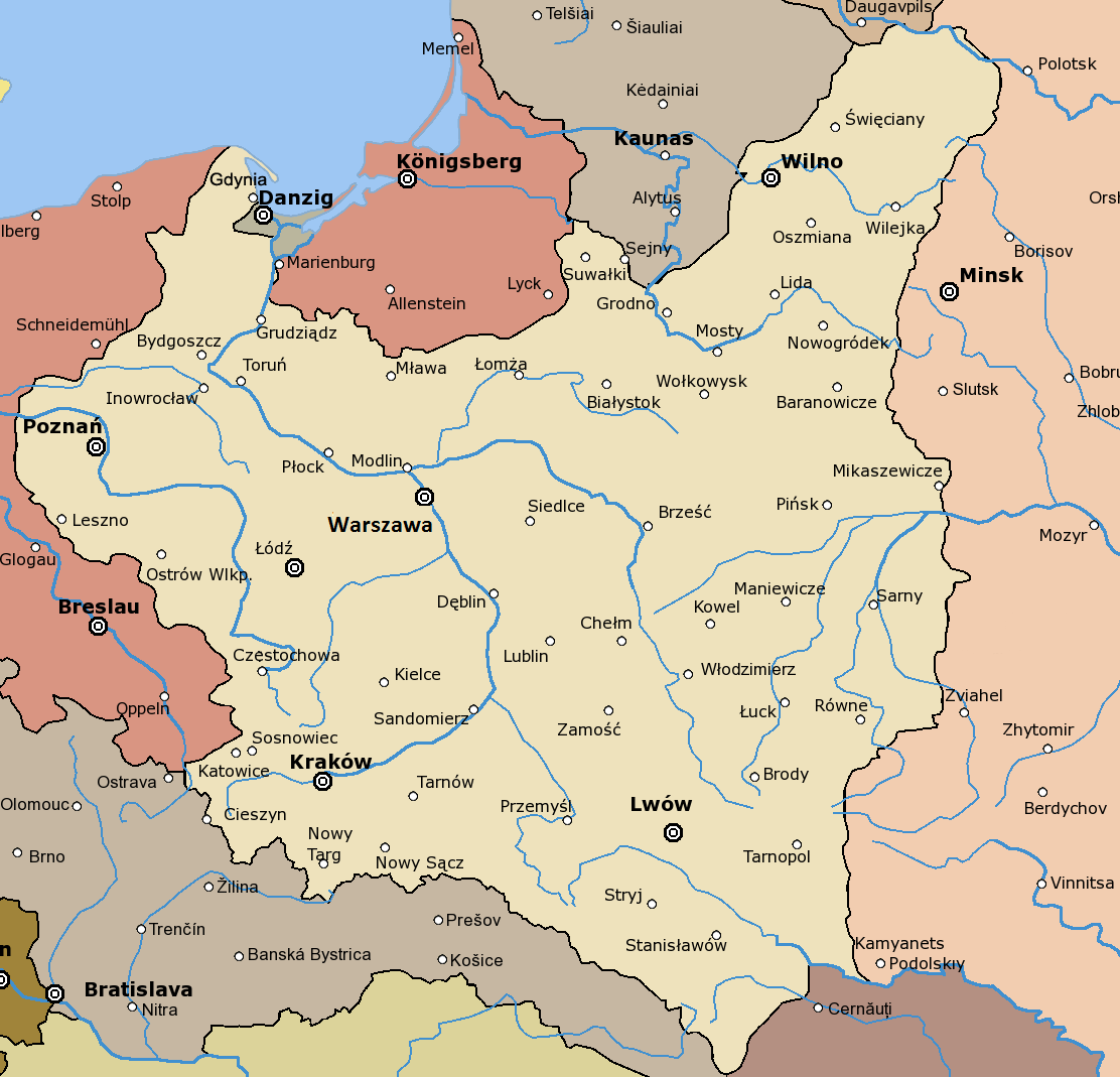 | ১,১১২ × ১,০৬৯ (১৮৬ কিলোবাইট) | smartcommons>Joanna Kośmider | Warsaw → Warszawa |
ফাইলের ব্যবহার
এই ফাইল ব্যবহার করে এমন কোনো পাতা নেই।
