চিত্র:Safavid Empire 1501 1722 AD.png

এই প্রাকদর্শনের আকার: ২২০ × ১৫২ পিক্সেল। অন্যান্য আকারসমূহ: ৩২০ × ২২১ পিক্সেল | ৬২০ × ৪২৮ পিক্সেল।
মূল ফাইল (৬২০ × ৪২৮ পিক্সেল, ফাইলের আকার: ২৪ কিলোবাইট, এমআইএমই ধরন: image/png)


|
This historical map image could be re-created using vector graphics as a SVG file. This has several advantages; see Commons:Media for cleanup for more information. If a SVG form of this image is available, please upload it and afterwards replace this template with
{{vector version available|new image name}}.It is recommended to name the SVG file “Safavid Empire 1501 1722 AD.svg”—then the template Vector version available (or Vva) does not need the new image name parameter. |
 Any autoconfirmed user can overwrite this file from the same source. Please ensure that overwrites comply with the guideline.
সারাংশ
| বিবরণSafavid Empire 1501 1722 AD.png | A map depicting the extent the Safavid Empire at its greatest extent. |
| তারিখ | ২৯ আগস্ট ২০০৭ (মূল আপলোডের তারিখ) |
| উৎস | নিজের কাজ |
| লেখক | ইংরেজি উইকিপিডিয়া-এর Arab League |
| অন্যান্য সংস্করণ | العربيَّة |

লাইসেন্স প্রদান
| Public domainPublic domainfalsefalse |

|
এই কাজের প্রণেতা ইংরেজি উইকিপিডিয়া-এর Arab League কাজটি পাবলিক ডোমেইনে প্রকাশ করেছেন। এটি বিশ্বব্যাপী প্রযোজ্য হবে। কিছু দেশে এটি আইনত সিদ্ধ নাও হতে পারে, যদি তাই হয়: Arab League যে-কাউকে যেকোনো উদ্দেশ্যে, বিনাশর্তে এই কাজটি ব্যবহারের অনুমতি প্রদান করেন, যদি না সেই শর্তগুলো আইনত প্রয়োজনীয় হয়।Public domainPublic domainfalsefalse |
মূল আপলোড লগ
en.wikipedia থেকে কমন্সে স্থানান্তরিত করা হয়েছে KureCewlik81 কর্তৃক।
মূল বিবরণ পাতাটি এখানে ছিল। নিম্নলিখিত সকল ব্যবহারকারীর নাম en.wikipedia-এ উল্লেখ করা ছিল।

- 2007-08-29 21:55 Arab League 620×429×8 (24314 bytes)
ক্যাপশন
এই ফাইলটি কী উপস্থাপন করছে তার এক লাইন ব্যাখ্যা যোগ করুন
Safavid empire
ئیمپراتۆریەتیی سەفەوی
ফাইলের ইতিহাস
যেকোনো তারিখ/সময়ে ক্লিক করে দেখুন ফাইলটি তখন কী অবস্থায় ছিল।
| তারিখ/সময় | সংক্ষেপচিত্র | মাত্রা | ব্যবহারকারী | মন্তব্য | |
|---|---|---|---|---|---|
| বর্তমান | ০০:২৭, ২৫ অক্টোবর ২০২৫ | 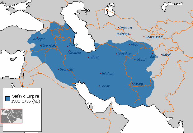 | ৬২০ × ৪২৮ (২৪ কিলোবাইট) | smartcommons>Average kurd | i put iraq fully under the safavid empire because of this [https://www.google.iq/books/edition/Asia_Inside_Out/3-iaBQAAQBAJ?hl=en&gbpv=1&dq=battle+of+hamadan+1503&pg=PA55&printsec=frontcover] and i added bahrain to the safavid empire |
ফাইলের ব্যবহার
এই ফাইল ব্যবহার করে এমন কোনো পাতা নেই।
