চিত্র:Spread sugarcane.JPG

এই প্রাকদর্শনের আকার: ২২০ × ১১৩ পিক্সেল। অন্যান্য আকারসমূহ: ৩২০ × ১৬৪ পিক্সেল | ৪৮৩ × ২৪৮ পিক্সেল।
মূল ফাইল (৪৮৩ × ২৪৮ পিক্সেল, ফাইলের আকার: ১৬ কিলোবাইট, এমআইএমই ধরন: image/jpeg)

|
This map image could be re-created using vector graphics as a SVG file. This has several advantages; see Commons:Media for cleanup for more information. If a SVG form of this image is available, please upload it and afterwards replace this template with
{{vector version available|new image name}}.It is recommended to name the SVG file “Spread sugarcane.svg”—then the template Vector version available (or Vva) does not need the new image name parameter. |


সারাংশ
| বিবরণSpread sugarcane.JPG |
English: Author: User:Bless_sins.
Source: I saw this map in:
Use rationale: I made it myself. The template map was free-use.
(islands west of Africa, circled by violet lines) |
| তারিখ | ১০ এপ্রিল ২০০৮ (মূল আপলোডের তারিখ) |
| উৎস |
en.wikipedia থেকে কমন্সে স্থানান্তরিত করা হয়েছে Teratornis কর্তৃক CommonsHelper ব্যবহার করে।
Cambridge University Press. p. 16. |
| লেখক | ইংরেজি উইকিপিডিয়া-এর Bless sins |
লাইসেন্স প্রদান
ইংরেজি উইকিপিডিয়া-এর Bless sins, এই কাজের স্বত্বাধিকারী, এতদ্দ্বারা এই কাজকে নিম্ন বর্ণিত লাইসেন্সের আওতায় প্রকাশিত করেছেন:


এই ফাইলটি ক্রিয়েটিভ কমন্স অ্যাট্রিবিউশন-শেয়ার অ্যালাইক ৩.০ আনপোর্টেড লাইসেন্সের আওতায় লাইসেন্সকৃত।
স্বীকৃতিপ্রদান:
- আপনি স্বাধীনভাবে:
- বণ্টন করতে পারেন – এ কাজটি অনুলিপি, বিতরণ এবং প্রেরণ করতে পারেন
- পুনঃমিশ্রণ করতে পারেন – কাজটি অভিযোজন করতে পারেন
- নিম্নের শর্তাবলীর ভিত্তিতে:
- স্বীকৃতিপ্রদান – আপনাকে অবশ্যই যথাযথ স্বীকৃতি প্রদান করতে হবে, লাইসেন্সের একটি লিঙ্ক সরবরাহ করতে হবে এবং কোনো পরিবর্তন হয়েছে কিনা তা নির্দেশ করতে হবে। আপনি যেকোনো যুক্তিসঙ্গত পদ্ধতিতে এটি করতে পারেন। কিন্তু এমন ভাবে নয়, যাতে প্রকাশ পায় যে লাইসেন্সধারী আপনাকে বা আপনার এই ব্যবহারের জন্য অনুমোদন দিয়েছে।
- একইভাবে বণ্টন – আপনি যদি কাজটি পুনঃমিশ্রণ, রুপান্তর, বা এর ওপর ভিত্তি করে নতুন সৃষ্টিকর্ম তৈরি করেন, তবে আপনাকে অবশ্যই আপনার অবদান একই লাইসেন্স বা একই রকমের লাইসেন্সের আওতায় বিতরণ করতে হবে।
মূল আপলোড লগ
মূল বিবরণ পাতাটি এখানে ছিল। নিম্নলিখিত সকল ব্যবহারকারীর নাম en.wikipedia-এ উল্লেখ করা ছিল।

- 2008-04-10 04:58 Bless sins 483×248× (16233 bytes) Author: User:Bless_sins. Source: I saw this map in: Watson, Andrew. ''Agricultural innovation in the early Islamic world''. [[Cambridge University Press]]. p. 16. Looking at it I drew an approximation. Use rationale: I made it myself. The template map was
ক্যাপশন
এই ফাইলটি কী উপস্থাপন করছে তার এক লাইন ব্যাখ্যা যোগ করুন
The spread of the cultivation of sugarcane
ফাইলের ইতিহাস
যেকোনো তারিখ/সময়ে ক্লিক করে দেখুন ফাইলটি তখন কী অবস্থায় ছিল।
| তারিখ/সময় | সংক্ষেপচিত্র | মাত্রা | ব্যবহারকারী | মন্তব্য | |
|---|---|---|---|---|---|
| বর্তমান | ১১:০২, ৭ অক্টোবর ২০০৯ | 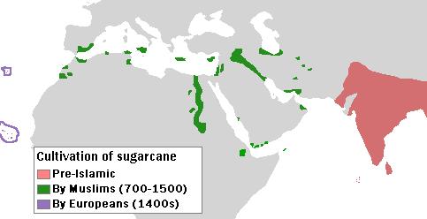 | ৪৮৩ × ২৪৮ (১৬ কিলোবাইট) | smartcommons>File Upload Bot (Magnus Manske) | {{BotMoveToCommons|en.wikipedia|year={{subst:CURRENTYEAR}}|month={{subst:CURRENTMONTHNAME}}|day={{subst:CURRENTDAY}}}} {{Information |Description={{en|Author: User:Bless_sins. Source: I saw this map in: Watson, Andrew. ''Agricultural innovation in the ea |
ফাইলের ব্যবহার
এই ফাইল ব্যবহার করে এমন কোনো পাতা নেই।
