চিত্র:Tibetan empire greatest extent 780s-790s CE.png

এই প্রাকদর্শনের আকার: ২২০ × ১৬৭ পিক্সেল। অন্যান্য আকারসমূহ: ৩১৬ × ২৪০ পিক্সেল | ১,৭৯২ × ১,৩৬১ পিক্সেল।
মূল ফাইল (১,৭৯২ × ১,৩৬১ পিক্সেল, ফাইলের আকার: ৪.৫৫ মেগাবাইট, এমআইএমই ধরন: image/png)

সারাংশ

|
This historical map image could be re-created using vector graphics as a SVG file. This has several advantages; see Commons:Media for cleanup for more information. If a SVG form of this image is available, please upload it and afterwards replace this template with
{{vector version available|new image name}}.It is recommended to name the SVG file “Tibetan empire greatest extent 780s-790s CE.svg”—then the template Vector version available (or Vva) does not need the new image name parameter. |
| বিবরণTibetan empire greatest extent 780s-790s CE.png |
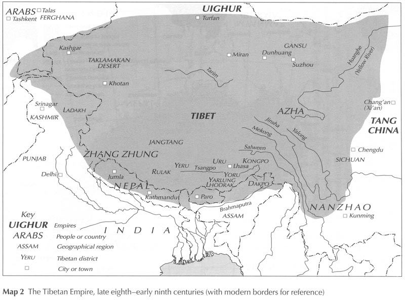
English: Map of the Tibetan Empire at its greatest extent between the 780s and the 790s CE
sources:
|
| তারিখ | |
| উৎস | নিজের কাজ |
| লেখক | Javierfv1212 |



লাইসেন্স প্রদান
আমি, এই কাজের স্বত্বাধিকারী, এতদ্দ্বারা আমি এই কাজকে নিম্ন বর্ণিত লাইসেন্সের আওতায় প্রকাশ করলাম:


এই ফাইলটি ক্রিয়েটিভ কমন্স অ্যাট্রিবিউশন ৩.০ আনপোর্টেড লাইসেন্সের আওতায় লাইসেন্সকৃত।
- আপনি স্বাধীনভাবে:
- বণ্টন করতে পারেন – এ কাজটি অনুলিপি, বিতরণ এবং প্রেরণ করতে পারেন
- পুনঃমিশ্রণ করতে পারেন – কাজটি অভিযোজন করতে পারেন
- নিম্নের শর্তাবলীর ভিত্তিতে:
- স্বীকৃতিপ্রদান – আপনাকে অবশ্যই যথাযথ স্বীকৃতি প্রদান করতে হবে, লাইসেন্সের একটি লিঙ্ক সরবরাহ করতে হবে এবং কোনো পরিবর্তন হয়েছে কিনা তা নির্দেশ করতে হবে। আপনি যেকোনো যুক্তিসঙ্গত পদ্ধতিতে এটি করতে পারেন। কিন্তু এমন ভাবে নয়, যাতে প্রকাশ পায় যে লাইসেন্সধারী আপনাকে বা আপনার এই ব্যবহারের জন্য অনুমোদন দিয়েছে।
ক্যাপশন
এই ফাইলটি কী উপস্থাপন করছে তার এক লাইন ব্যাখ্যা যোগ করুন
Map of the Tibetan Empire at its greatest extent between the 780s and the 790s CE
Mapa del Imperio Tibetano en su Mayor Extensión entre los años de 780s y 790s C.E.
En büyük sınırlarında Tibet İmparatorluğu, MS. 780'ler-790'lar
ফাইলের ইতিহাস
যেকোনো তারিখ/সময়ে ক্লিক করে দেখুন ফাইলটি তখন কী অবস্থায় ছিল।
| তারিখ/সময় | সংক্ষেপচিত্র | মাত্রা | ব্যবহারকারী | মন্তব্য | |
|---|---|---|---|---|---|
| বর্তমান | ২১:৪১, ১৬ জানুয়ারি ২০২১ |  | ১,৭৯২ × ১,৩৬১ (৪.৫৫ মেগাবাইট) | smartcommons>Liandrei | Cropped black border |
ফাইলের ব্যবহার
এই ফাইল ব্যবহার করে এমন কোনো পাতা নেই।
