চিত্র:Vichy france map.png

এই প্রাকদর্শনের আকার: ২১৯ × ৯৬ পিক্সেল। অন্যান্য আকারসমূহ: ৩২০ × ১৪০ পিক্সেল | ১,৪২৫ × ৬২৫ পিক্সেল।
মূল ফাইল (১,৪২৫ × ৬২৫ পিক্সেল, ফাইলের আকার: ৫০ কিলোবাইট, এমআইএমই ধরন: image/png)

সারাংশ
| বিবরণVichy france map.png |
English: Map of Vichy France and the loss of its territory to Free France and the Axis powers. Legend:
日本語: フランスの領土・植民地のうちヴィシーフランスと自由フランス、枢軸国占領地域の地図。凡例:
Русский: Карта Вишистской Франции и потеря ею территорий Свободной Франции и странам «Оси»:
Français : Carte de la France de Vichy et de la perte de ses territoires au profit de la France libre et des puissances de l'Axe. Légende :
|
| উৎস | |
| লেখক |
লাইসেন্স প্রদান
| Public domainPublic domainfalsefalse |

|
এই কাজের প্রণেতা ইংরেজি উইকিপিডিয়া-এর VoodooIsland কাজটি পাবলিক ডোমেইনে প্রকাশ করেছেন। এটি বিশ্বব্যাপী প্রযোজ্য হবে। কিছু দেশে এটি আইনত সিদ্ধ নাও হতে পারে, যদি তাই হয়: VoodooIsland যে-কাউকে যেকোনো উদ্দেশ্যে, বিনাশর্তে এই কাজটি ব্যবহারের অনুমতি প্রদান করেন, যদি না সেই শর্তগুলো আইনত প্রয়োজনীয় হয়।Public domainPublic domainfalsefalse |
মূল আপলোড লগ
মূল বিবরণ পাতাটি এখানে ছিল। নিম্নলিখিত সকল ব্যবহারকারীর নাম en.wikipedia-এ উল্লেখ করা ছিল।

- 2011-03-01 19:23 Morgan Hauser 1425×774× (58113 bytes) Added Franco-Belgian border, corrected Alsace-Lorraine, the Demarcation line and the Algerian internal boundary weren't country borders, Corsica was Vichy until 1942, corrected the Italian zone of occupation.
- 2010-07-11 20:50 VoodooIsland 1425×774× (63452 bytes) designate concessions (held by Vichy until 1943) in China
- 2010-07-11 20:10 VoodooIsland 1425×774× (63369 bytes) designate Algerian territory integral to French State vs that held as colony
- 2010-05-29 23:51 VoodooIsland 1425×774× (63306 bytes) Forgot to downgrade color of New Caledonia (Vichy gov. speedily extinguished)
- 2010-05-29 23:46 VoodooIsland 1425×774× (63302 bytes) +French territories '''never'' held by Vichy France (e.g., only [[French India]])
- 2010-05-29 23:43 VoodooIsland 1425×774× (63266 bytes) +Itallian occupation zone in southeast
- 2010-05-29 22:57 VoodooIsland 1425×774× (63239 bytes) +Alsace-Lorraine (Nazi occupied)
- 2010-05-29 22:48 VoodooIsland 1425×774× (63228 bytes) Nazi Germany occupied Northern part while formally part of the French State
- 2010-05-29 22:44 VoodooIsland 1425×774× (63159 bytes) '''Dark blue:''' ''De jure'' part of the '''French State''' ("[[Vichy France]]") '''Teal:''' ''De jure'' part of the '''French State''' ("[[Vichy France]]") under [[Fascist Italy|Italian]] occupation '''Light blue:''' [[League of Nations mandate|Mandate]]
| Annotations InfoField | This image is annotated: View the annotations at Commons |

770
185
45
50
1425
774
Operation Exporter took place in the League of Nations French Mandate for Syria and the Lebanon between 8 June and 14 July 1941.
670
306
39
57
1425
774
The League of Nations mandate of French Cameroun joined Free France on 27 August 1940.
ক্যাপশন
এই ফাইলটি কী উপস্থাপন করছে তার এক লাইন ব্যাখ্যা যোগ করুন
Gradual Loss of Vichy France's (French State) colonies
Perte graduelle des colonies françaises du régime de Vichy (État français)
ফাইলের ইতিহাস
যেকোনো তারিখ/সময়ে ক্লিক করে দেখুন ফাইলটি তখন কী অবস্থায় ছিল।
| তারিখ/সময় | সংক্ষেপচিত্র | মাত্রা | ব্যবহারকারী | মন্তব্য | |
|---|---|---|---|---|---|
| বর্তমান | ০২:৫৮, ২২ মে ২০১৭ | 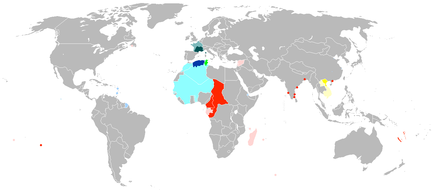 | ১,৪২৫ × ৬২৫ (৫০ কিলোবাইট) | smartcommons>Grachifan | cutting extra space at the bottom of the image |
ফাইলের ব্যবহার
এই ফাইল ব্যবহার করে এমন কোনো পাতা নেই।
