চিত্র:Zhenghe-sailing-chart.gif

এই প্রাকদর্শনের আকার: ২২০ × ১৫৭ পিক্সেল। অন্যান্য আকারসমূহ: ৩২০ × ২২৮ পিক্সেল | ১,৪৫৪ × ১,০৩৬ পিক্সেল।
মূল ফাইল (১,৪৫৪ × ১,০৩৬ পিক্সেল, ফাইলের আকার: ১৭৪ কিলোবাইট, এমআইএমই ধরন: image/gif)

সারাংশ
| বিবরণZhenghe-sailing-chart.gif |
English: Part of the Wu bei zhi chart of Zheng He showing the west coast of India along the top, Ceylon top right and Africa along the bottom. The sailing directions are shown using zhen lu compass directions.
Русский: Фрагмент навигационной карты ("карта Мао Куня") из энциклопедии "Убэй чжи", показывающий бассейн Аравийского моря.
Север слева, восток вверху. В правом верхнем углу - остров Цейлон (錫蘭山,Силаньшань - остров/гора Силань); в правом нижнем углу - порт Малинди (麻林地, Малиньди) |
| তারিখ | Early 15th century map. Published in Wubei Zhi in 1628. |
| উৎস | Wubei Zhi |
| লেখক |
লাইসেন্স প্রদান
| Public domainPublic domainfalsefalse |

|
এই কর্মটি এর উৎস দেশে পাবলিক ডোমেইনে রয়েছে এবং অন্যান্য দেশ ও অঞ্চলে যেখানে কপিরাটের সময়সীমা হচ্ছে লেখকের জীবন যোগ ১০০ বছর বা তাঁর কম।  You must also include a United States public domain tag to indicate why this work is in the public domain in the United States. You must also include a United States public domain tag to indicate why this work is in the public domain in the United States.
|
| এই ফাইলটি কপিরাইট আইনের আওতায় জানা সকল বাধানিষেধ মুক্ত বলে চিহ্নিত হয়েছে, যার মধ্যে সম্পর্কিত সকল স্বত্ব ও নেইবারিং সত্ত্ব সংযুক্ত। | |
https://creativecommons.org/publicdomain/mark/1.0/PDMCreative Commons Public Domain Mark 1.0falsefalse
মূল আপলোড লগ
মূল বিবরণ পাতাটি এখানে ছিল। নিম্নলিখিত সকল ব্যবহারকারীর নাম en.wikipedia-এ উল্লেখ করা ছিল।

- 2008-07-04 22:54 Chris55 1454×1036× (177834 bytes) Part of the Wu bei zhi chart of Zheng He showing the west coast of India along the top, Ceylon top right and Africa along the bottom. The sailing directions are shown using zhen lu compass directions.
ক্যাপশন
এই ফাইলটি কী উপস্থাপন করছে তার এক লাইন ব্যাখ্যা যোগ করুন
ফাইলের ইতিহাস
যেকোনো তারিখ/সময়ে ক্লিক করে দেখুন ফাইলটি তখন কী অবস্থায় ছিল।
| তারিখ/সময় | সংক্ষেপচিত্র | মাত্রা | ব্যবহারকারী | মন্তব্য | |
|---|---|---|---|---|---|
| বর্তমান | ১০:০০, ১ সেপ্টেম্বর ২০০৯ | 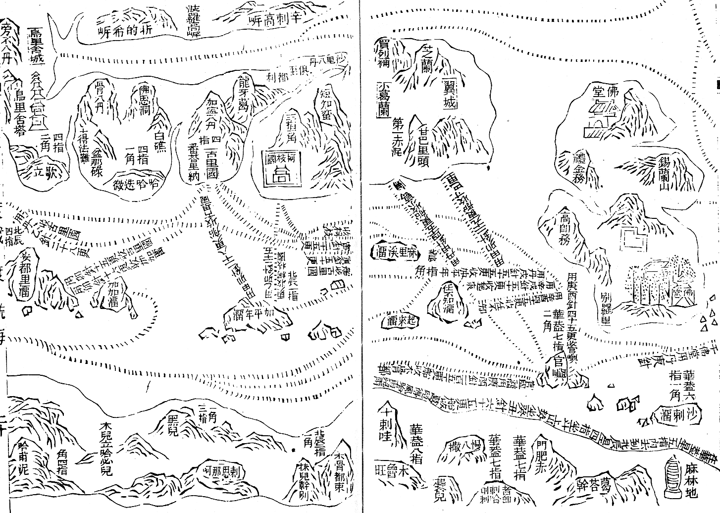 | ১,৪৫৪ × ১,০৩৬ (১৭৪ কিলোবাইট) | smartcommons>Rockfang | {{Information |Description={{en|Part of the Wu bei zhi chart of Zheng He showing the west coast of India along the top, Ceylon top right and Africa along the bottom. The sailing directions are shown using zhen lu compass directions.}} |Source=Transferred |
ফাইলের ব্যবহার
এই ফাইল ব্যবহার করে এমন কোনো পাতা নেই।
